Jordan Lake. This is the Jordan Dam tailrace this morning. The Army Corps of Engineers opened the dam gates and are letting the Haw River head on down stream. About 3 miles down stream the Haw River comes together with the Deep River and they then together become the Cape Fear River. It appears that it will be at least the end of next week or longer before boat ramps, fishing areas, camping sites, those kind of places around the lake will be open. It takes a while to move that much water out of the lake and down to the ocean.
water
CategoryLake Levels!
Water Levels at Jordan Lake. This morning at 9:00AM the lake was at 225.51 ft … that is 9.51 ft above the normal pool of 216 ft. As the level goes up the water floods the shore line further and further inland. This flooding is keeping me and other Army Corps bald eagle monitors from checking on nests. Sigh. I made the video from my truck at one of several boat ramps that I checked at the lake yesterday. BTW I believe all of the lake’s boat ramps are currently inaccessible for launching boats.
Mallard Paddle
It is New Year’s Eve and I wanted to share a quiet ending to this year with each of you. So, please enjoy the mallards as they serenely paddle Jordan Lake.
Doc Ellen’s Natural Minute
Jordan Lake. Sparkle/blinking beating heart/life of plant water sky … Is that shimmering light/persistence/showing somehow/roots found place/amongst jumbled rocks/thrusting living leaves/above lake’s waters
Transition
Here is where the current of the Haw River stops, and the river transitions into the ever changing depths of Jordan Lake. You can hear the river murmuring – perhaps wondering when its soliloquy will once again become heard as it passes through the Jordan Lake Dam. My thanks to Captain Doug for bringing me to the beauty of this place so I could share it with all of you.
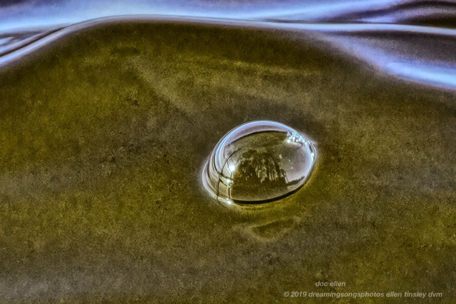
Jordan Lake Reflection
Doc Ellen’s Palette (I don’t think I will ever entirely grow up…) I was chasing water bubbles, made in the waves by the passing boats, and simply seeing if I could stop the bubbles’ sliding motion. What I didn’t realize was just how much reflection of the shoreline I was also recording. In the bubble: that is the sun to the left, because I am looking south, and the shoreline I am sitting on and its tall trees cross the diameter of the bubble. There are even a few clouds to the right/north in the reflection.